
I can’t now recall whether I’d ever even heard of Appenzell before I moved to Switzerland though it’s renowned within the country for all things pastoral — its beer and cheese for instance, and its velvetty, undulating topography.
And then there are the countless ancient rustic Swiss traditions — like making it impossible for visitors to park a car for more than 15 minutes in one place.
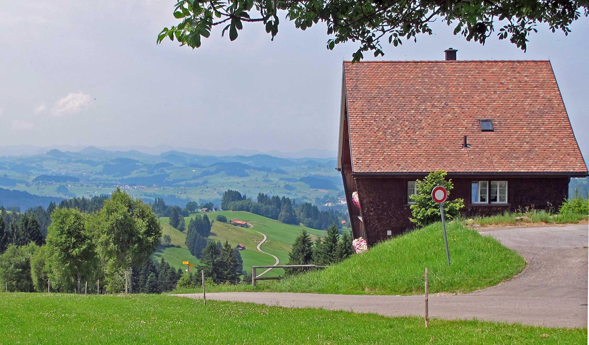
I was here just two weeks ago with M, when the hills, and the famous appeal of the region, were hidden by a thick curtain of rain and fog, and the highlight of our afternoon was a visit to the supermarket — its car park had proved irresistible. Now, in the sunshine, this small town and the Kanton of the same name are transformed, and charming enough to be forgiven.
Switzerland is famous for its cheese, though not quite as famous as it thinks it is. In my whispered opinion, a triumph of quantity over quality. Nothing at all wrong with most, but for an Englander raised on Stilton and farmhouse Cheddar, most Swiss stuff is a bit bland and samey. A good mature Appenzeller is one of the exceptions, and could comfortably break bread with a decent mid-range Cheddar without dying of embarrassment. I have a soft spot for it. It was the first cheese I bought in Switzerland, within an hour of our arrival in Zurich in October 2010.
And so it was good to finally shake hands with the place today. Appenzell was to be the start and end point of my proposed walk – Stage 2 of the Alpine Panorama Trail, Switzerland’s National Trail Number 3.
Like last week when I parked in Trogen and made my way to the start, today I drove the 90 minutes or so to Appenzell, parked, and took the train back to Trogen, changing again in St Gallen. I’d arrived in plenty of time to make the 10:08 to St Gallen, but trying to offload the car made me miss that one and nearly the next one, 30 minutes later. Eventually, I abandoned the thing in a school playground, ensuring I’d spend the rest of the day worrying about them shutting and locking the gates before I returned.
Between Appenzell and St Gallen, I took the opportunity of removing a shoe and sock, and slathering some Vaseline between the toes while an elderly lady looked on with three parts disdain and one part fascination. Before the operation was complete, the train stopped at the village of Teufen and about 40 boisterous young teenagers crowded into the carriage, filling every available crevice with their bright blue teeshirts announcing Teufen Handball Camp 2013. This mysterious game is big in these parts. The influx meant the Vaseline smear campaign had to stop, and the second foot had to wait for the second leg, between St Gallen and Trogen.
The only other thing of note on the first train was a poster advertising a music festival in the town featuring none other than Uriah Heep, celebrated rockers of my youth. So from stadium gigs across the globe through the 70s and 80s, they are now not just playing the village square in Appenzell, but appear to be lower down the pecking order than Al-Berto & The Fried Bikinis.
Despite the public toe lubrication, I’d been more organised this week. Food needed more thought than I’d realised last time, so today my packed lunch was in the fridge and ready to go before I got up. Homemade pecan nut butter on rye bread, boiled eggs, cornichons, olives, tomatoes, walnuts, prunes and sesame snaps — to be washed down with diluted orange juice or water. No it doesn’t sound too complicated, but I had to find things that didn’t dishonour my current food religion, then pack them all into unsquashable containers in an arrangement that didn’t juxtapose the wrong flavours.
With better advance planning, I was out of the house by about 08:30 — two hours earlier than last week. It’s an hour and a half to Appenzell if you take the scenic route, away from Zurich and the autobahn, and instead thread your way through the numerous flag-waving villages and narrow lanes that spiral up around the lush hillsides. It was going to be hot again, around 30, though a couple of degrees less than last week.
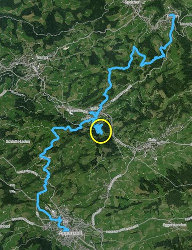
At Trogen, I marched back down to the village square and the distinctive church. I’d been confident about where the route picked up from last week, but a few minutes into the trek, I was already doubting my inner compass. This set the tone for the day. The walk was full of improvised meanderings. Some were forced on me (more of that later); some the product of bad signage or tracks that simply vanished in the long grass; and some the result of bad judgment on my part.
About 20 minutes out of Trogen the path I should have started on finally appeared, but like my sudden smugness, didn’t last long. The track led away from the metalled road and into a dense wood where the grassy trail became increasingly overgrown and indistinct, eventually evaporating completely. I was lost, and resorted to hauling myself up a steep muddy bank in search of a beaten track, using the thinner willowy saplings as handholds. As the canopy of trees grew thicker and darker, I batted away a faint sense of claustrophobia, struggling further up the slope into ever thicker woods until I reached that state occasionally experienced on a very crowded tube train, when you no longer have to hold on to anything, but are sustained by the crush.
Then finally, just moments from panic, I burst through the solid foliage like a Champagne cork being released from a shaken bottle. Amazed, I found myself spilt across a real track that would merge with the official signposted trail just 200 metres or so further on. Hurrah! A serene stretch followed, leading me to a lookout point and small restaurant – Hohe Buche (High Beech).
The view across the wave of hills was glorious but today I was to be a participant, not a spectator. With the briefest of stops to glance at the information board explaining the names of the distant peaks, I plunged headlong into the movie before anyone could stop me. The path took me down into a deep valley, crossing beautiful open countryside between farms and desolate barns. It was a lovely environment, but I couldn’t deny the suspicion that once again I’d strayed from the hiking script. The path had petered out again, and when the distinctive yellow Wanderweg sign did finally reappear, there was no mention of Path No. 3 or any destination I recognised.
I must have gone wrong at Hohe Buche. I briefly thought about retracing my steps but couldn’t face the long haul back up the wall of the valley. Instead I headed in what I presumed was the right direction, and hoped for the best. Twenty minutes later, on the floor of the valley, at a junction of two trails, I took a left-hander and wandered upwards again, through fenceless fields and past empty houses, until I found more crossed paths and another sign. Here at least, one of the options – Bühler – was a place I had on my route, so I took the Bühler path and hoped for better luck.
The trail undulated all the way to the Buhler, with the ground underfoot changing from tarmacked lane to narrow farm track to faint grassy hillside path. A passing jogger offered a violent Shearer salute; a tractor 3 metres wide came up behind me on a walled farm road that was 3.1 metres wide; and I encountered my first Swiss stile — an old turnstile guarded by a few cattle. These were the highlights on the road to the next village.
It was now after 2pm, and the sun was starting to weigh on me like an extra rucksack. The hot spell continued without respite for the next 5 or 6 hours. I was thirsty, but didn’t want to interrupt the momentum to stop and get a drink from my backpack. Not good practice. I recalled the advice from my running days, that you should never allow yourself to feel thirsty. Thirst means dehydration, and dehydration is not good. So hydration strategy is something to add to my lengthening ‘must think about’ list.
My new daypack (a Deuter Trail 32, as you ask) does have an aperture for a hose and pocket for the reservoir, but I’d chosen to use the apace to store an iPad, with bottles of fluid in the two side pockets instead — and therefore out of reach when the pack is on my back. I have a water belt, but am reluctant to strap on anything else. Maybe it will be cooler next week, releasing me from decision making.
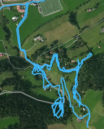
Another item on this list is getting smarter about orienteering. I’ve not used a compass or proper map on this walk yet. On Stage 1 I used screenshots of maps saved to my phone; on this second day I used paper versions of the same. The trouble with taking screenshots of the route only is that you lose sight of the bigger picture, and when you stray off the path, or are forced to change the route, you can stray off the map as well, making it harder to find your way back. These problems had already made themselves known on this walk, but the best illustration was still to come, on the paths above Buhler.
Unusually for Switzerland, the village didn’t seem to have a natural centre. The arrangement reminded me of a typical small American town — just a main road with a few shops strung out along it, and a handful of curious locals sitting outside the coffeshop, staring at the stranger. Maybe there is more to the place, but I didn’t have time to discover it. I hastened towards the footpath sign that pointed me along the tracks, behind the station, then off towards the hills beyond. Long story short: after climbing the steep track that led out of the town, past the painted panels and the hand-made sign to encourage pilgrims on the Via Jakobiweg — the path that stretches across Europe to Camino de Santiago in Spain — I found myself in an exasperating dead end, where I would waste nearly two hours wandering round in circles.
Before the trouble revealed itself, I found a bench to enjoy an ascetic lunch of pecan nut-butter on rye, blueberries and a boiled egg, swilled away with nearly a litre of diluted fruit juice. The fluid was badly needed; I’d been walking on empty for more than an hour. On the other wall of the valley, the path was clear — a pale grey line that vanished over the brow of the near hill before reappearing more faintly, snaking up a second hill in the far distance. There was something cartoonishly enticing about the prospect, but I wouldn’t get to experience it. I missed the significance of the bulldozers visible lower down the closest hillside.
I soon set off again, pushing past an incredulous cow, but didn’t get much further. The path vanished upwards into a small rutted slope and a few metres later, an electric fence. Beyond it, I could see another. This wasn’t going to work. With no signs to guide me, I returned to the path and took the only other route available (not including the option to walk all the way down the hill to Buhler again). This meant creeping through a small farmyard while the sound of playful family chatter could be heard on the other side of a low fence. The possibility of hearing a shotgun being loaded proved to be an excellent performance-enhancing aid, and within moments I was through the other side of the yard and making my way down a dizzily steep farm track.
This soon became a proper tarmacked lane, and all seemed well. And then I saw it. Or rather, I didn’t see it because it wasn’t there. The path around the side of the steep hill ceased to exist. Instead, a gap of about 20 metres and a drop into space. The prime suspect, a big red bulldozer, sat and stared at me, without displaying the merest flicker of shame. Gah! I retraced my steps and found another path alongside a noisy stream, but this immediately led to nothing but a dense wall of forestry. No option but to climb back up the very steep lane and tiptoe rapidly through the farmyard again.
Back to my lunch bench for an emergency one-man conference. I would have to make my way back in the direction of the village, but seek out all paths on the way. And so I did, but each of the three or four exits came to nothing. They were either glorified driveways of private houses, or they looped round and led straight back to the path I was on. With a sense of bitter disappointment and failure, I realised I’d no alternative but to return to the village and find a bus or train to take me to the next village, or even all the way back to Appenzell.
I’d now been walking for four hours, but was only halfway to my destination. Four hours is roughly the estimated time for the entire stage, which made me feel a bit better. Too bad that I’d have to take the train to Appenzell, but at least I’d put in my shift. But at the bottom of the hill, just before reaching the village again, I came across a Wanderwerg sign I must have walked straight past earlier, without noticing. On the sign, someone had helpfully written the warning: Gesperrt (“Blocked”). At least it confirmed that I’d tried going the right way. A second footpath sign pointed to the right of the road I’d just descended. “Appenzell”, it stated. For a few seconds, I wasn’t sure how to react to this alternative path, as my head had started to attune to the decision to point myself at the station. But almost immediately, I’d made my mind up and headed off away from the village, and towards Appenzell. 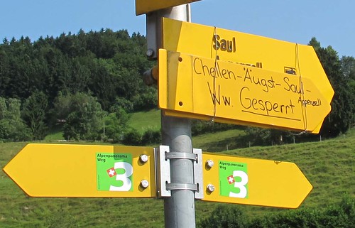 The remainder of the walk was pedestrian. I tramped up a long but benign hill, through a straggly wood, and down the other side. Along a gravel path, round a corner, and onto a small metalled road with a sign telling me that Appenzell was just an hour away. By now I was tired, and ready to hit my destination soon. If I’d felt more sprightly I might have improvised a more adventurous route down to the town, but for a while I was happy with the lane. At least I was confident I would get there this way.
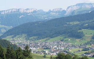 Around another corner and here, at last, was Appenzell. But down there, not up here. Confusingly, the closest sign said it was still an hour away, and this was at least 20 minutes on from the last ‘hour to Appenzell’ sign. I should have felt frustrated, but the view down into the valley was too spectacular to make any room for grumpiness. … a superb panorama with the town sprawled across the valley floor beneath the a wooded hillside and beyond, a formidable wall of rocky mountains, acting like a barricade to hold off Mondays and project deadlines. It reminded me of the Himalayas, and other locations suddenly jerked from long hibernation in the memory archive, where small towns lie low in just this way, hidden in deep valleys between towering folds of rocks. You can see where the creators of fantasy games and epochal ‘sims’ like Civilization get their inspiration from.
This story is almost over. For the final part of the descent I found a small but well-maintained path which wound me through a string of farmyards and alongside a small river for a while. It was still hot and clammy when I finally reached the outskirts of the town. I was badly dehydrated, with crunchy salt encrusted round my mouth. I spotted a gas station and bought a bottle of ice-cold grapefruit-and-water drink, too dry to even issue a thank you to the cashier. Oh my. I think I would trade that glass of ’78 Penfold’s Grange Hermitage, or even the Palmer tasting, for those 50 centilitres of life restoring fluid.
Final stats: Total duration, including stops: 7 hours 29 minutes. Total duration, not including stops: 5 hours 36 minutes. Distance walked: 25.61 kms. Ascent: 905 metres Descent: 1028 metres Heart rate: min – 73 max – 154 ave – 114.
********** Footnote: the Bühler merry-go-round:
4 comments On Alpine Panorama Trail — Stage 2: Trogen to Appenzell
I found this to be a really good reference book:
http://www.amazon.co.uk/Ultimate-Navigation-Manual-Lyle-Brotherton/dp/0007424604/ref=cm_cr_pr_product_top
Just a question of securing the right maps and getting a decent compass. There are fixed orienteering courses near us from parks to fells that help you practice your nav. I wonder if there are any nearby in Horgen?
Bravo! Good work, Mr.Cheese.
Good question. I resorted to my phone at one point, just to make sure I wasn’t where I thought I wasn’t, but I’m very keen not to start whipping it out every time I’m unsure. I used it once on the first walk too, because it was getting late and I needed to know I was heading in the right direction.
But after last week’s problems, I’ve decided I need something to help, so I’ve gone old school and dug out a compass. Haven’t used this for many years.
I just finished the final bit which I’ll post tomorrow morning, before I head off to Urnasch for the 3rd leg between Appenzell and there.
Thanks for the company…
Hurrah! Our hero rejects the train and continues on foot towards the glorious cheese. I love it when the head makes a decision but then it gets overruled. It may not lead to happiness, but it leads to experience.
Btw, surely a being of your technological advancement could navigate by GPS? Or is that just not cricket?